Gulf of Finland
The Gulf of Finland (Finnish: Suomenlahti; Estonian: Soome laht; Russian: Фи́нский зали́в, tr. Finskiy zaliv, IPA: [ˈfʲinskʲɪj zɐˈlʲif]; Swedish: Finska viken) is the easternmost arm of the Baltic Sea. It extends between Finland (to the north) and Estonia (to the south) all the way to Saint Petersburg in Russia, where the river Neva drains into it. Other major cities around the gulf include Helsinki and Tallinn. The eastern parts of the Gulf of Finland belong to Russia, and some of Russia's most important oil harbours are located farthest in, near Saint Petersburg (including Primorsk). As the seaway to Saint Petersburg, the Gulf of Finland has been and continues to be of considerable strategic importance to Russia. Some of the environmental problems affecting the Baltic Sea are at their most pronounced in the shallow gulf.
Geography
The area of the gulf is 30,000 km2 (12,000 sq mi). The length (from the Hanko Peninsula to Saint Petersburg) is 400 km (250 mi) and the width varies from 70 km (43 mi) near the entrance to 130 km (81 mi) on the meridian of Moshchny Island; in the Neva Bay, it decreases to 12 km (7.5 mi). The gulf is relatively shallow with the depth decreasing from the entrance to the gulf to the continent. The sharpest change occurs near Narva-Jõesuu, which is why this place is called Narva wall. The average depth is 38 m (125 ft) with the maximum of 100 m (330 ft). The depth of the Neva Bay is less than 6 metres (20 ft); therefore, a channel was dug at the bottom for safe navigation. Because of the large influx of fresh water from rivers, especially from the Neva River (two-thirds of the total runoff), the gulf water has very low salinity – between 0.2 and 5.8 ‰ at the surface and 0.3–8.5 ‰ near the bottom. The average water temperature is close to 0 °C in winter; in summer, it is 15–17 °C (59–63 °F) at the surface and 2–3 °C (36–37 °F) at the bottom. Parts of the gulf can be frozen from late November to late April; the freezing starts in the east and gradually proceeds to the west. Complete freezing is usually reached by late January, and it might not occur in mild winters. There are frequent strong western winds causing waves, surges of water and floods.
The northern coast of the gulf is high and winding, with abundant small bays and skerries, but only a few large bays (Vyborg) and peninsulas (Hanko and Porkkalanniemi). The coast is mostly sloping; there are abundant sandy dunes, with occasional pine trees. The southern shores are smooth and shallow, but along the entire coast runs the Baltic Klint with the height up to 55 m (180 ft). In the east, the gulf ends with Neva Bay and on the west merges with the Baltic Sea.
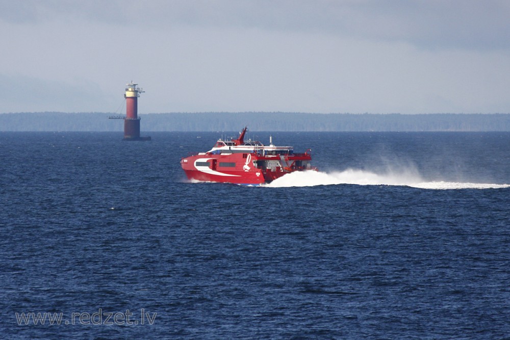
The gulf contains numerous banks, skerries and islands. The largest include Kotlin Island with the city of Kronstadt (population 42,800), Beryozovye Islands, Lisiy Island, Maly Vysotsky Island with the nearby city of Vysotsk (population 1706), Hogland (Suursaari), Moshtchny (Lavansaari), Bolshoy Tyuters (Tytärsaari), Sommers, Naissaar, Kimitoön, Kökar, Seskar (Seiskari), Pakri Islands and others.
Starting from 1700, nineteen artificial islands with fortresses were built in the gulf by Russia. Their purpose was defense from attacks from water and their construction was urged by the Great Northern War of 1700–1721. Those include Fort Alexander, Krasnaya Gorka, Ino, Totleben, Kronshlot and others.[9]
The largest rivers flowing into the gulf are Neva (from the east), Narva (from the south), and Kymi (from the north). Keila, Pirita, Jägala, Kunda, Luga, Sista and Kovashi flow into the gulf from the south. From the north flow Sestra River, Porvoo, Vantaa and several other small rivers. Saimaa Canal connects the gulf with the Saimaa lake
en.wikipedia.org